Watches /
RWI-W-SALISH
Regional benchmark — Salish Sea
Salish Sea
RWI-W-SALISH-2026-11-01flights 2026-10-31
- 1 foreign military aircraft in the area (Canada).
- Heat inside bp Cherry Point refinery 2026-10-31 0941 UTC (FRP 1.12).
- Heat inside bp Cherry Point refinery 2026-11-01 0943 UTC (FRP 1.64).
- Heat inside bp Cherry Point refinery 2026-11-01 0943 UTC (FRP 2.26).
- Heat inside bp Cherry Point refinery 2026-11-01 1025 UTC (FRP 1.24).
7 US military · 52 other low · 1 foreign military · 1 state/VIP · 222 heat (4 on sites)
 CFB Esquimalt
 NAS Whidbey Island – Ault Field (KNUW)
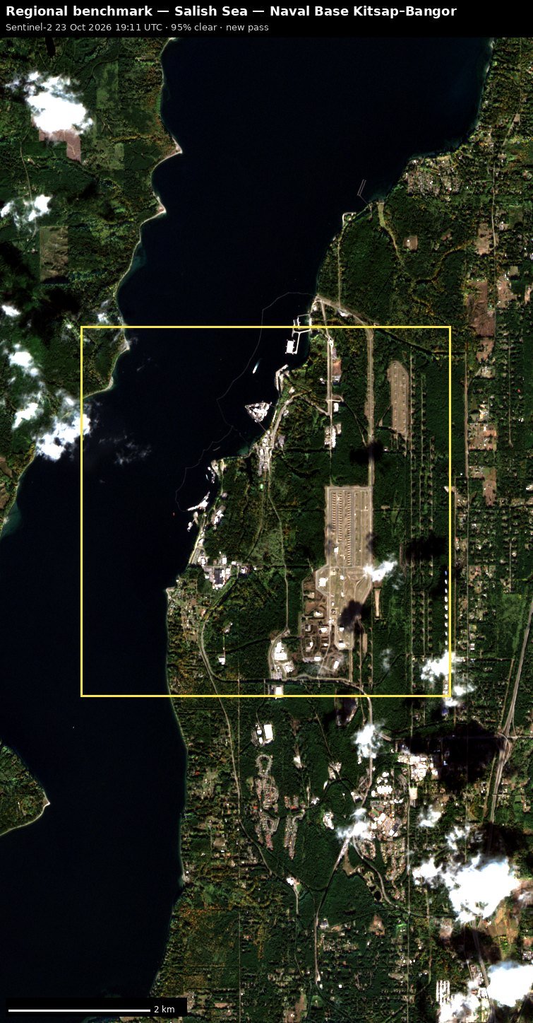 Naval Base Kitsap–Bangor
 OLF Coupeville
 Naval Base Kitsap–Bremerton / Puget Sound Naval Shipyard
Full report
Salish Sea. Daily open-source look; flights for 2026-10-31 (UTC), heat for 2026-10-31–2026-11-01, newest satellite passes. LLM-generated and automated.
Notable
- 1 foreign military aircraft in the area (Canada).
- Heat inside bp Cherry Point refinery 2026-10-31 0941 UTC (FRP 1.12).
- Heat inside bp Cherry Point refinery 2026-11-01 0943 UTC (FRP 1.64).
- Heat inside bp Cherry Point refinery 2026-11-01 0943 UTC (FRP 2.26).
- Heat inside bp Cherry Point refinery 2026-11-01 1025 UTC (FRP 1.24).
Flights
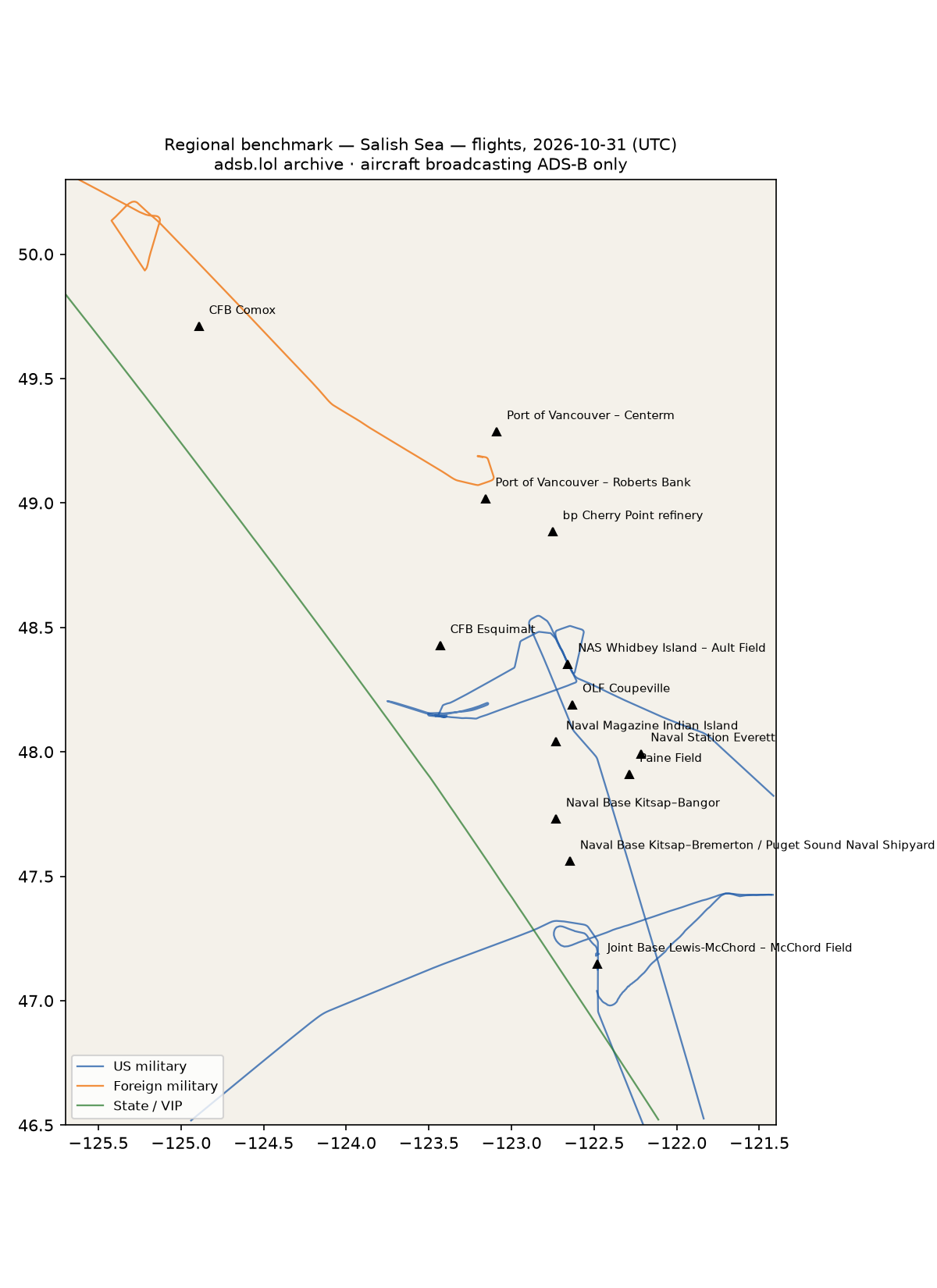
61 aircraft kept: 7 US military, 1 foreign military, 1 state/VIP, 52 other (on the ground at a site, or near a range).
US military
C17 ×3, AS65 ×2, BE20 ×1, B737 ×1.
- 10-0216 C17 RCH203 RCH232 at Joint Base Lewis-McChord – McChord Field 17:05 UTC
- 168206 BE20 TORII79 at Joint Base Lewis-McChord – McChord Field 01:09 UTC
- 166694 B737 CNV4118 at NAS Whidbey Island – Ault Field 04:01 UTC
- 6592 AS65 C6592 at NAS Whidbey Island – Ault Field 19:16 UTC
Foreign military
- Canada: C-FMFX BE9L MSTG97 15:53–16:57 UTC
State and VIP
- UR-82027 A124 ANTONOV An-124 Ruslan ADB503F 17:00–17:34 UTC
Landings and low passes by site
| Site | Military / government aircraft on the ground or ≤1,500 ft within 4 km; civil count |
|---|---|
| CFB Esquimalt | 2 civil |
| CFB Comox (19 Wing) | — |
| NAS Whidbey Island – Ault Field (KNUW) | 166694 B737 (CNV4118) 04:01, 6592 AS65 (C6592) 19:16 |
| OLF Coupeville | — |
| Naval Base Kitsap–Bangor | — |
| Naval Base Kitsap–Bremerton / Puget Sound Naval Shipyard | — |
| Naval Station Everett | 1 civil |
| Joint Base Lewis-McChord – McChord Field (KTCM) | 168206 BE20 (TORII79) 01:09, 10-0216 C17 (RCH203 RCH232) 17:05 |
| Port of Vancouver – Roberts Bank (Deltaport / Westshore) | — |
| Port of Vancouver – Centerm (DP World) | — |
| Naval Magazine Indian Island | — |
| bp Cherry Point refinery | — |
| Paine Field | 43 civil |
Heat
222 detections in the watch box (FIRMS area API (agent Gazda)); 4 inside a site box. Pre-alpha sample basis (frozen 2 Nov 2026).
| Date | UTC | Lat, lon | FRP | Satellite | Site / nearest |
|---|---|---|---|---|---|
| 2026-10-31 | 0941 | 48.885, -122.740 | 1.12 | N | bp Cherry Point refinery |
| 2026-10-31 | 1000 | 47.570, -122.342 | 0.57 | N20 | Naval Base Kitsap–Bremerton / Puget Sound Naval Shipyard (22.7 km) |
| 2026-10-31 | 1041 | 47.568, -122.342 | 1 | N21 | Naval Base Kitsap–Bremerton / Puget Sound Naval Shipyard (22.8 km) |
| 2026-10-31 | 1947 | 49.089, -124.760 | 4.91 | N20 | CFB Comox (19 Wing) (69.6 km) |
| 2026-10-31 | 2029 | 48.743, -124.226 | 3.35 | N21 | CFB Esquimalt (68.2 km) |
| 2026-10-31 | 2029 | 48.770, -124.143 | 6.69 | N21 | CFB Esquimalt (64.8 km) |
| 2026-10-31 | 2029 | 48.774, -124.146 | 6.69 | N21 | CFB Esquimalt (65.2 km) |
| 2026-10-31 | 2029 | 48.914, -123.854 | 23.35 | N21 | Port of Vancouver – Roberts Bank (Deltaport / Westshore) (52.1 km) |
| 2026-10-31 | 2029 | 48.916, -123.847 | 14.3 | N21 | Port of Vancouver – Roberts Bank (Deltaport / Westshore) (51.6 km) |
| 2026-10-31 | 2029 | 48.918, -123.855 | 23.35 | N21 | Port of Vancouver – Roberts Bank (Deltaport / Westshore) (52.1 km) |
| 2026-10-31 | 2032 | 48.899, -124.204 | 6.69 | N21 | CFB Esquimalt (77.4 km) |
| 2026-10-31 | 2032 | 48.901, -124.213 | 27.62 | N21 | CFB Esquimalt (78.0 km) |
| 2026-10-31 | 2032 | 48.903, -124.208 | 11.11 | N21 | Port of Vancouver – Roberts Bank (Deltaport / Westshore) (77.7 km) |
| 2026-10-31 | 2032 | 48.904, -124.202 | 11.11 | N21 | Port of Vancouver – Roberts Bank (Deltaport / Westshore) (77.3 km) |
| 2026-10-31 | 2032 | 48.905, -124.215 | 27.62 | N21 | Port of Vancouver – Roberts Bank (Deltaport / Westshore) (78.2 km) |
| 2026-10-31 | 2032 | 48.906, -124.202 | 9.54 | N21 | Port of Vancouver – Roberts Bank (Deltaport / Westshore) (77.2 km) |
| 2026-10-31 | 2032 | 48.908, -124.204 | 11.11 | N21 | Port of Vancouver – Roberts Bank (Deltaport / Westshore) (77.4 km) |
| 2026-10-31 | 2032 | 48.932, -124.183 | 34.95 | N21 | Port of Vancouver – Roberts Bank (Deltaport / Westshore) (75.4 km) |
| 2026-10-31 | 2032 | 48.933, -124.178 | 24.99 | N21 | Port of Vancouver – Roberts Bank (Deltaport / Westshore) (75.1 km) |
| 2026-10-31 | 2032 | 48.935, -124.189 | 24.95 | N21 | Port of Vancouver – Roberts Bank (Deltaport / Westshore) (75.9 km) |
| 2026-10-31 | 2032 | 48.936, -124.185 | 24.95 | N21 | Port of Vancouver – Roberts Bank (Deltaport / Westshore) (75.5 km) |
| 2026-10-31 | 2032 | 48.937, -124.180 | 21.5 | N21 | Port of Vancouver – Roberts Bank (Deltaport / Westshore) (75.2 km) |
| 2026-10-31 | 2032 | 49.096, -124.774 | 2.89 | N21 | CFB Comox (19 Wing) (68.7 km) |
| 2026-10-31 | 2108 | 47.571, -122.370 | 3.39 | N | Naval Base Kitsap–Bremerton / Puget Sound Naval Shipyard (20.7 km) |
| 2026-10-31 | 2108 | 48.749, -124.229 | 2.29 | N | CFB Esquimalt (68.8 km) |
| 2026-10-31 | 2108 | 48.770, -124.147 | 3.96 | N | CFB Esquimalt (65.1 km) |
| 2026-10-31 | 2108 | 48.772, -123.484 | 5.37 | N | Port of Vancouver – Roberts Bank (Deltaport / Westshore) (36.2 km) |
| 2026-10-31 | 2108 | 48.773, -124.148 | 3.96 | N | CFB Esquimalt (65.3 km) |
| 2026-10-31 | 2108 | 48.898, -124.205 | 12.21 | N | CFB Esquimalt (77.3 km) |
| 2026-10-31 | 2108 | 48.901, -124.212 | 31.18 | N | CFB Esquimalt (77.9 km) |
| 2026-10-31 | 2108 | 48.902, -124.207 | 12.21 | N | Port of Vancouver – Roberts Bank (Deltaport / Westshore) (77.7 km) |
| 2026-10-31 | 2108 | 48.903, -124.201 | 12.21 | N | Port of Vancouver – Roberts Bank (Deltaport / Westshore) (77.3 km) |
| 2026-10-31 | 2108 | 48.903, -124.219 | 24.43 | N | CFB Esquimalt (78.4 km) |
| 2026-10-31 | 2108 | 48.904, -124.213 | 24.43 | N | Port of Vancouver – Roberts Bank (Deltaport / Westshore) (78.1 km) |
| 2026-10-31 | 2108 | 48.906, -124.203 | 11.21 | N | Port of Vancouver – Roberts Bank (Deltaport / Westshore) (77.3 km) |
| 2026-10-31 | 2108 | 48.907, -124.197 | 7.31 | N | Port of Vancouver – Roberts Bank (Deltaport / Westshore) (76.9 km) |
| 2026-10-31 | 2108 | 48.920, -123.849 | 7.54 | N | Port of Vancouver – Roberts Bank (Deltaport / Westshore) (51.7 km) |
| 2026-10-31 | 2108 | 48.924, -123.851 | 2.15 | N | Port of Vancouver – Roberts Bank (Deltaport / Westshore) (51.7 km) |
| 2026-10-31 | 2108 | 48.933, -124.186 | 4.69 | N | Port of Vancouver – Roberts Bank (Deltaport / Westshore) (75.6 km) |
| 2026-10-31 | 2108 | 48.934, -124.180 | 4.69 | N | Port of Vancouver – Roberts Bank (Deltaport / Westshore) (75.2 km) |
Imagery
| Site | Newest clear Sentinel-2 pass (≤12 days) | |
|---|---|---|
| CFB Esquimalt | 2026-10-28 19:21 UTC, 79% clear | new plate |
| CFB Comox (19 Wing) | none clear | |
| NAS Whidbey Island – Ault Field (KNUW) | 2026-10-21 19:21 UTC, 100% clear | new plate |
| OLF Coupeville | 2026-10-21 19:21 UTC, 100% clear | new plate |
| Naval Base Kitsap–Bangor | 2026-10-23 19:11 UTC, 95% clear | new plate |
| Naval Base Kitsap–Bremerton / Puget Sound Naval Shipyard | 2026-10-28 19:11 UTC, 93% clear | new plate |